3D Golf services for Architects, Green renovations, Irrigation and Design companies

3D Golf Services


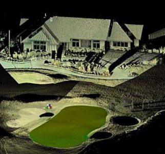
Figure 1: Scanned Point Cloud with a 3D Face Rendered Mesh for the green area. Over 1.6 million points captured at surveyed grade accuracies.
Figure 2: Point Cloud with 70,000 X,Y,Z points and .1’ contours.
Figure 3: 3D green rendered mesh, Point Cloud and 3D Wire frame.
Figure 4: 3D green rendered mesh, 3D Wire frame, Point Cloud and .1’ contours.
Figure 5: Full 3D green rendered mesh and Point Cloud.
Figure 6: 3D green rendered mesh, .1’ full contours, and Point Cloud.
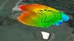
Figure 7: High definition slope green analysis
Figure 8: High definition slope green analysis
Figure 9: 3D Full Green area contour analysis with aerial photo coverage
Figure 10: 3D Full Green area Digital Elevation Model with aerial photo coverage
Figure 11: High definition slope green analysis with aerial photo coverage
Figure 12: High definition slope green analysis
Figure 13: 3D Full Green area Digital Elevation Model, contours, sprinkler heads with aerial photo coverage
Figure 14: GPS data base of point of interest. All digital data Google Earth compatible
<
>
Golf Course Maps in 3D
Golf course designers and managers use accurate, detailed maps of their golf course as-built to better manage the course. This is a great launching point for golf course re-design. You can also order 3-D Golf Course Maps of your course design. These maps are particularly useful in planning your new golf course design, as they show we can show such things as
Fly over your new golf course design to see a birds eye view before it's built.
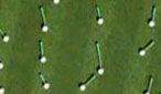
See a preview of the roll patterns of balls dropped on the green
Experience flying over your newly-designed golf course in full color with greens information right on the map.
Take the next step to make golf course management and planning much easier for all those involved! Point North’s expertise in Mapping, GIS and Land Surveying gives us the unique skill set to help you with planning and upgrading an existing course or a brand new one. We emphasize the importance of communication among the various members of your organization from golf course planners to the end users -- the golfers themselves.
You'll receive a product that is exactly what all entities need for present and future planning. as well as keeping the planning process smooth and organized. Our customers include Golf Course Architects, Course Renovators, Shaping, Irrigation and Design companies, among others.
Point North’s HD Golf Land Surveying uses a survey-based scanning technology, RTK GPS and robotic total stations to capture all the detailed information necessary to meet the demands of each particular design project.
3D Golf Scans
Our newest technology combined with our field data collection methods has revolutionized 3D green scanning, promoting us to the leading edge of the 3D green scanning industry.
RTK GPS
We use highly accurate GPS equipment to locate your Green areas, irrigation systems, water flow catch basin, impervious surfaces and as-builts.
Applications for HD Green Contouring Land Surveying:
- Architectural Plans
- Compare as-built greens to designed layout
- Compare as-built greens to renovated greens
- 3D Digital elevation modeling
- Valuable slope information
- Precise pin locations
- Historical Maintenance
- Superintendent maintenance, Wall maps and or digital files
- Site Grading and Cut/Fill applications
More applications for our HD Surveying:
- Detailed maps for Golf Tournaments
- Club house display maps
- Video graphics applications
- Web site applications
- Survey grade yardage information
- Golf Simulators
Digital Files for Architects, Renovations and Irrigation companies
- CAD .dwg or .dxf files
- Microstation export files
- Land .xml files
- Almost all image files for easy Web and Graphics integration
Greens Keepers. Meet your new best friend.
- improve the health of your greens
- streamline the process of pin locations
- keep your regular golfers engaged
- create more challenging pin locations
- no need to work from memory
- maximize and optimize the number of pins on your greens
Start right now to make your job easier, more accurate and better for your golfers and let the compliments begin.

Related Services:
Point North Inc also is a Land Surveying firm with full GPS, Mapping and GIS capabilities.
We would be able to offer turnkey services from the beginning to the end of your project.
Please get in touch for pricing relating to our services outlined on this page
3D Golf Scanning/RTK GPS Land Surveying/ GIS mapping
Please contact me for any questions or a project estimate,
Todd

VIEW VIDEO
VIEW VIDEO
© Copyright Point North Land Surveying and Mapping Inc. All rights reserved.
CONTACT